Manipur


| Country | |
|---|---|
| Established | 21 January 1972 |
| Capital | Imphal |
| Largest city | Imphal |
| Districts | 9 |
| Government | |
| • Governor | Gurbachan Jagat |
| • Chief Minister | Okram Ibobi Singh (INC) |
| • Legislature | Unicameral (60 seats) |
| • Parliamentary constituency | 2 |
| • High Court | Gauhati High Court |
| Area | |
| • Total | 22,347 km2 (8,628.2 sq mi) |
| Area rank | 23rd |
| Population (2011) | |
| • Total | 2,721,756 |
| • Rank | 22nd |
| • Density | 121.8/km2 (315.4/sq mi) |
| Time zone | IST (UTC+05:30) |
| ISO 3166 code | IN-MN |
| HDI | |
| HDI rank | 5th (2005) |
| Literacy | 79.85% (2011 Census) |
| Official languages | Meiteilon |
Manipur is a state in northeastern India, with the city of Imphal as its capital. Manipur is bounded by the Indian states of Nagaland to the north, Mizoram to the south and Assam to the west; it also borders Burma to the east. It covers an area of 22,347 square kilometres (8,628 sq mi)..
The Meiteis (Meeteis), who live primarily in the state's valley region, form the primary ethnic group (60% of the total population) but occupy only 10% of the total land area. Their language, Meiteilon (Meeteilon), (also known as Manipuri), is also the lingua franca in the state, and was recognized as one of the national languages of India in 1992. The Muslims (Meitei-Pangal) also live in the valley; the Kukis, Nagas, Paites and other smaller groups form about 40% of the population but occupy the remaining 90% of the total land area of Manipur State . Manipur is considered a sensitive border state.
Foreigners entering Manipur prior to January 1, 2011 (including foreign citizens born in Manipur) were required to possess Restricted Area Permit. As of January 1, 2011 foreign citizens are no longer required to have a Protected Areas Permit (PAP). This change will remain in effect for one year.

Manipur is one of the seven states of Northeast India, and one of the Seven Sister States. The state is bounded by Nagaland in the north, by Mizoram in the south, by Assam in the west, and by the borders of the country Burma in the east as well as in the south. The state capital of Manipur is Imphal. The state lies at latitude of 23°83’N – 25°68’N and longitude of 93°03’E – 94°78’E. The total area covered by the state is 22,347 km². The capital lies in an oval-shaped valley of approximately 700 square miles (2,000 km2) surrounded by blue mountains and is at an elevation of 790 metres above the sea level. The slope of the valley is from north to south. The presence of the mountain ranges not only prevents the cold winds from the north from reaching the valley but also acts as a barrier to the cyclonic storms originating from the Bay of Bengal.


There are four major river basins in Manipur State, the Barak River Basin (Barak Valley) to the west, the Manipur River Basin in central Manipur, the Yu River Basin in the east, and a portion of the Lanye River Basin in the north.The total water resources of Barak and Manipur river basins are about 1.8487 Mham. The overall water balance of the state amounts to 0.7236 Mham in the annual water budget. (By way of comparison, India receives 400 Mham (million hectare meters) of rain annually The Barak river, the largest river of Manipur, originates in the Manipur Hills and is joined by a number of tributaries such as the Irang,Maku, and Tuivai. After its junction with the Tuivai, the Barak River turns north and forms the border with Assam State, and then enters the Cachar Assam just above Lakhipur. The Manipur river basin has eight major rivers: the Manipur, Imphal, Iril, Nambul,Sekmai, Chakpi, Thoubal and Khuga. All these rivers originate from the surrounding hills.
Almost all the rivers in the valley area are in the mature stage and, therefore, deposit their sediment load in the Loktak lake.The rivers draining the Manipur Hills are comparatively young, due to the hilly terrain through which they flow. These rivers are corrosive in nature and assume turbulent form in the rainy season. Important rivers draining the western area include the Maku, Barak, Jiri, Irang and Leimatak. Rivers draining the eastern part of the state, the Yu River Basin, include the Chamu, Khunou and other short streams.


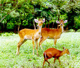
Physiographically, Manipur may be characterised in two distinct physical regions – an outlying area of rugged hills and narrow valleys, and the inner area of flat plain, with all associated land forms. These two areas are not only distinct in respect of physical features but are also conspicuous with regard to various flora and fauna. The valley region would have been a monotonous, featureless plain but for a number of hills and mounds rising above the flat surface. The Loktak lake is an important feature of the central plain. The total area occupied by all the lakes is about 600 km². The altitude ranges from 40 m at Jiribam to 2,994 m at Mt. Iso Peak near Mao Songsong.
The soil cover can be divided into two broad types, viz. the red ferruginous soil in the hill area and the alluvium in the valley. The valley soils generally contain loam, small rock fragments, sand and sandy clay, and are quite varied. On the plains, especially flood plains and deltas, the soil is quite thick. The top soil on the steep slopes is very thin. Soil on the steep hill slopes is subject to high erosion, resulting in gullies and barren rock slopes. The normal pH value ranges from 5.4 to 6.8. The climate of the State is salubrious with approximate average annual rainfall varying from 933 mm at Imphal to 2593 mm at Tamenglong. The temperature ranges from sub-zero to 36°C


The climate of Manipur is largely influenced by the topography of this hilly region which defines the geography of Manipur. Lying 790 meters above sea level, Manipur is wedged between hills on all sides. This northeastern corner of India enjoys a generally amiable climate, though the winters can be a little chilly. The maximum temperature in the summer months is 32 degree C. In winter the temperature often falls below zero, bringing frost. Snow sometimes falls in some hilly regions due to the Western Disturbance. The coldest month is January, and the warmest July. The ideal time for tourism in the state, in terms of climate, is from October to February, when the weather remains bright and sunny without the sun being too hot.
The state is drenched in rains from May until mid-October. It receives an average annual rainfall of 1467.5 mm. However, the rain distribution varies from 933 mm in Imphal to 2593 mm in Tamenglong. The precipitation ranges from light drizzles to heavy downpour. The normal rainfall of Manipur enriches the soil and helps in agricultural processes and irrigation. The South Westerly Monsoon picks up moisture from the Bay of Bengal and heads toward Manipur, hits the eastern Himalaya rangesand produces a massive amount of rain in the state.